Flood Watch – Johnston
Until 09:00 AM ET
Change the text and make it your own. Click here to begin editing.
800x500.png)


LATEST STORIES
Forecasts, severe weather coverage, and storm recaps from across North Carolina

NCWA Staff · July 21, 2026 · 2 min read
Alright guys, let's talk, since it appears everyone in their brother and 3rd cousin once removed has plans this week and into the weekend! Unfortunately, if you have outdoor plans, you'll be at the mercy of Mother Nature for the next few days. An approaching front will bring a very active period of weather through Saturday at least across North Carolina, and if you haven’t had rain yet by Saturday, I am pretty confident you'll have rainfall! WHAT: A front will move into the state and stall...
Active Weather is ahead; rounds of storms are likely, with some Flash Flooding possible.
General

General
Another active day ahead for our Sunday!
⛈️ Storm Update: Here we go again, another active afternoon and evening is expected across parts of the state. A cold front will approach the region from the north later today. This, along with increasing CAPE (Convective available potential energy) to over 2,000 J/kg, will result in scattered showers and thunderstorms developing. We should have an unstable lapse rate, meaning the rate at which atmospheric temperature decreases with increasing altitude, this afternoon and evening. Gusty winds...
NCWA STAFF
JUL 19

General
Strong to severe storms possible this afternoon and evening.
⛈️ Severe Weather Update: Heat and humidity, along with outflow boundaries left over from storms moving through the Ohio Valley, will allow scattered showers and thunderstorms to develop this afternoon and evening across the state and push east. A couple could be strong to severe, with damaging winds being the main threat. The Storm Prediction Center has placed most of North Carolina under a level 2/5 risk of severe weather, and the rest of the state under a level 1/5 risk. 📌WHAT: Cape...
NCWA STAFF
JUN 27

Deep Dive
What Meteorologists are Looking For on Radar During Severe Weather
We've all experienced it - gathering around the TV as the broadcast meteorologist goes through a list of cities and towns in the path of a tornado-warned storm. But how do meteorologists know when to warn a storm? What are meteorologists looking for? If you've ever driven past a National Weather Service office, there's likely one thing that stood out - a NEXRAD (Next-Generation Radar) doppler radar. The NEXRAD Radar at Fort Fix in New Jersey A Brief History of Weather Radar Prior to the...
Caden Nelson
Jun 17, 2026

General
Summer comes roaring in with near record high temperatures ahead
Welcome to Summer in North Carolina. If you're new around here, you'll figure out what that means quickly. Here comes the heat, the hottest temperatures in over a year are on the way for most of the state. Heat and humidity will build through the week, with the highest humidity and heat on Thursday and Friday, and slightly cooler, less humid air for the weekend, though still hot. Above-average to near-record temperatures are possible across the state, especially Thursday and Friday. The only...
NCWA STAFF
JUN 10

General
North Carolina Holiday Weekend Forecast
THE NORTH CAROLINA HOLIDAY WEEKEND FORECAST: First things first, it is not a washout anywhere, don't let those dumb weather app icons force you to cancel your plans. Be flexible and have a backup, but we will be just fine! It is active, and if you have several hours of outdoor plans, you might have to deal with a thunderstorm, especially in inland areas. Saturday: A couple of isolated showers are possible Saturday morning along the coast and parts of Central and Western NC, then it should be...
NCWA STAFF
MAY 22

General
Summer is making an early appearance
Summer is making an early appearance! It'll be cooler this week, highs in the 60s and 70s generally, but high pressure is about to build in and turn on the heat! Temperatures are set to soar this weekend into next week with highs in the 80s and 90s across most of the state, a little cooler in the mountains and coastal areas. We will start off with a drier heat, but humidity levels will return later next week. Maybe some PM storm chances at some point late next week, but no significant...
NCWA STAFF
MAY 11

General
Wednesday: Scattered showers around first then maybe a risk of strong to severe storms.
Hey everyone, let's talk about the Wednesday forecast. There could be a couple of strong-to-severe storms on Wednesday afternoon, especially across the Central/Northern parts of Eastern NC, but it is far from certain! I'll explain that a shortwave will move through the state tomorrow morning, early morning across the mountains and foothills, and through the morning across Central and Eastern sections. It'll bring clouds and scattered showers, no severe weather expected with this round. 📌This...
NCWA STAFF
APR 28

General
The week ahead turning hot again.
The Weather Headlines across the great state of North Carolina for everyone, don't be caught unaware! Today is a more active, cooler day with scattered showers, some storms, and widespread clouds. We will begin to see a change in the weather starting Tuesday. -Tuesday, the cold front breaks down, we will start to see a ridge of high pressure build back, and some sunshine returns to most of the state. Highs will be in the 80s to near 90° for most areas. Storm/rain chances are much lower, but a...
NCWA STAFF
JUL 13

General
Strong to severe storm chance mainly across Eastern NC on Tuesday.
⛈️ Severe Weather Update: Another round of strong to severe storms is possible today, but this time the threat shifts east and northeast into Eastern sections of the state. The Storm Prediction Center has upgraded the severe weather risk, placing most areas east and northeast of Raleigh under a level 2/5 risk and a level 1/5 risk for the rest of Central NC to about Greensboro. Why? Well, an approaching cold front moving into the mountains will trigger showers and thunderstorms this afternoon...
NCWA STAFF
JUN 23

Daily Forecast
SUNDAY: Chance for strong to severe thunderstorms this afternoon and evening
Hot and humid conditions will fuel scattered thunderstorms this afternoon and evening, with a few storms capable of producing damaging winds. Not everyone will see rain, but if you have outdoor plans, stay weather-aware and have multiple ways to receive warnings. Slightly cooler air arrives to start the week.
NCWA STAFF
JUN 14

General
A very nice period of weather is on the way!
Our Weather Headlines for the rest of the week, a very nice period of weather is on the way. Wednesday & Thursday will feature rather low humidity with highs in the 70s and 80s for most areas under mostly sunny skies. Friday: It'll be a little warmer, with highs in the 80s and 90s across most of the state, cooler along the coast and in the higher mountains. Overnight lows over the next few days will cool off nicely thanks to low humidity levels. Saturday & Sunday: Partly to mostly sunny skies...
NCWA STAFF
JUN 2

General
The rest of the week into the weekend turning more active
⛈️ Let's talk about late week into the Holiday Weekend. I know there is a ton going on, and the weather greatly impacts most events! Here's my thoughts as of now: No, it won't be a washout, and no it won't rain all day, everyday by any means. The weekend itself is looking like a very typical summertime setup across NC! Wednesday: Another hot day is expected with highs in the 80s and 90s; most stay dry today. However, a couple of showers and thunderstorms can't be ruled out, mainly across...
NCWA STAFF
MAY 20

General
Forecast Wednesday May 6th.
A new day is ahead, it'll be a changing one. Happy Wednesday, North Carolina! We will see partly to mostly cloudy skies for most of the state this morning into midday. A few scattered showers will be around the west, with an isolated passing shower into Central NC late morning to around lunch; otherwise, quiet. Highs will warm into the 70s and 80s for most of the state, with cooler temps to the west thanks to more clouds and some rain around. A cold front will move into the state later today,...
NCWA STAFF
MAY 6

General
Still in need of a lot more rain to end the drought
So, how much rain do we need to get out of this drought? Well Ethan it has storm at my place several times recently so is the drought over? While the rain we’ve had is better than nothing, to completely wipe out the drought in a month, most of the state would need over 10 inches of rain. Numbers are higher when you spread it out over 2 plus months. It is highly unlikely this would happen in a month at this point. I used the latest rainfall data to create this map. It is not exact, as there...
NCWA STAFF
JUL 10

General
Tropical Storm Arthur forms will bring life-threatening flooding to the gulf coast and some moisture to NC.
Tropical Update: Tropical Storm Arthur becomes the first Tropical Storm of the 2026 season about 30 miles ENE of Port Oconnor along the Texas Gulf Coastline. The remains of Arthur and an approaching cold front could bring some gusty winds and scattered rain/storm chances to North Carolina Thursday night into Friday. I'll have more on this post. There's far too much hype with this system; we will be just fine in the Carolinas. Tropical Storm Arthur is mainly a rainstorm with a name because it...
NCWA STAFF
JUN 17

Daily Forecast
Hot and humid day ahead with showers and storms possible.
Welcome to summer in North Carolina. The hottest weather in over a year is on the way, with heat and humidity peaking Thursday and Friday. Slightly cooler, less humid air arrives this weekend, but temperatures will remain hot. Near-record highs are possible.
NCWA STAFF
JUN 12

General
Additional scattered showers and thunderstorms are possible on Tuesday which could result and localized Flash flooding.
The risk of heavy downpours and some localized Flash Flooding is back today for parts of the state. It is hot and humid! As we continue to have heating and a very saturated atmosphere, scattered showers and thunderstorms will develop once again today. We know there will be a burst of heavy rainfall and even the potential for some flash flooding, but with this setup and our tools today, we can't pinpoint exactly where the Flash Flooding or heavy rainfall will occur. I've created a map in image...
NCWA STAFF
MAY 26
General
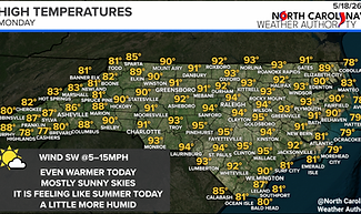
Turning hotter and sunny for our Monday across North Carolina!
Summer is making an appearance today and this week across most of the state. Happy Monday, North Carolina! Those summer days in North Carolina have returned, and we will see mostly sunny skies today. Bermuda high pressure will be firmly in control of our weather, and highs will soar into the 80s and 90s for most of the state. A little cooler along the coast, thanks to the sea breeze from the cooler ocean temps, and cooler in the higher elevations of the mountains. A little increase in...
NCWA STAFF
MAY 18

General
Rain is looking more likely across the state on Saturday, and it's cold!
🌧️ SATURDAY: The rain dances are working! One word to say, it's gonna rain on Saturday across the state. A good soaking rain seems to be on the way for the state, especially across Central and Eastern sections on Saturday. Another round of much-needed rainfall! A coastal low will develop and move along the coast, and it'll spread rain northwestward late Friday night into Saturday morning. I expect most areas across the state to be raining on Saturday morning, and the rain will gradually pull...
NCWA STAFF
APR 30
CADEN NELSON

110°F
110°F
Raleigh area
110°F
110°F
Raleigh area
110°F
110°F
Raleigh area
110°F
110°F
Raleigh area
110°F
110°F
Raleigh area
110°F
110°F
Raleigh area
110°F
110°F
Raleigh area
110°F
110°F
Raleigh area
110°F
110°F
Raleigh area
110°F
110°F
Raleigh area
110°F
110°F
Raleigh area
110°F
110°F
Raleigh area
110°F
110°F
Raleigh area
110°F
110°F
Raleigh area
110°F
110°F
Raleigh area
110°F
110°F
Raleigh area
110°F
110°F
Raleigh area
110°F
110°F
Raleigh area
110°F
110°F
Raleigh area
110°F
110°F
Raleigh area


