


Hurricane Erin Update: Impacts likely for the coastline
- Ethan Clark

- Aug 19, 2025
- 4 min read
Hurricane Erin Update: Good evening, everyone. My latest update on Erin. The good news is that there have not been any last-minute changes, and the forecast remains on track. Erin is locked 615 Miles SSE of Cape Hatteras and has winds of 105MPH at a Category 2 Hurricane with a pressure of 958MB. It is now moving NNW, so those TikToks that you saw that said it would turn and hit land are of course wrong lol.

-Over the course of the day, as expected, the storm has gotten bigger, which means while we will not see a direct landfall in North Carolina, coastal impacts are still expected.
-There is no reason to panic, we will be just fine and get through this storm like always.
-This evening's high tide brought some minor ocean overwash to parts of the coast, but I expect the bulk of the worst ocean conditions to be with the high tides on Wednesday and Thursday.
--One thing to note, I don’t mention rain impacts or tornadoes like they usually do with hurricanes. I still think most rain will remain just offshore, but a couple of outer bands of rain, some heavy at times, will rotate onto the coast, especially parts of the Outer Banks, on Wednesday and Thursday. Tornados with hurricanes only form on the right sides, which’ll be in the middle of the ocean. The main flooding concerns are from saltwater, not freshwater. See in my photos how not many rainbands are expected. (image 4)

🌊 Ocracoke, Hatteras, Buxton, Avon, Waves, Rodanthe, Oregon Inlet
(Greatest impacts Wednesday into Thursday, especially around high tides)
-Storm Surge: 2–4 ft surge with life-threatening ocean overwash likely.
-Rip Currents: Dangerous rip currents through Friday with surf up to 20 ft. Severe beach erosion expected.
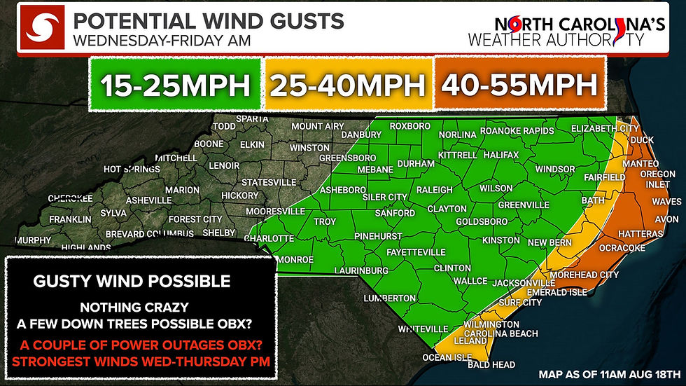
-Wind: Gusts 40–55 mph on Wednesday/Thursday may cause scattered power outages.
-Travel: Highway 12 and side roads may be impassable for extended periods due to flooding and overwash.
📌MORE INFO:
• Ferries: Service likely impacted throughout midweek/late week.
• Extreme beach/coastal erosion and damage expected along oceanside.
• Large waves will destroy dune structures.
• Floodwaters may extend inland, flooding homes, businesses, and roads.
• Vehicles may be submerged.
• Protective actions to safeguard life and property will be necessary.

🌊 Nags Head, Kill Devil Hills, Kitty Hawk, Southern Shores, Duck, Corolla (Greatest impacts Wednesday into Thursday especially around high tides)
-Storm Surge: 2–4 ft surge possible with ocean overwash, mainly Wednesday/Thursday.
-Rip Currents: High rip current risk through Friday. Surf 8–15 ft, beach erosion likely.
-Wind: Gusts 40–55 mph Wednesday/Thursday could lead to some power outages.
-Travel: Some road flooding is possible during high tide, but less severe than in areas to the south.
-The most significant impacts are expected along Ocracoke, Hatteras, and south of Oregon Inlet, where flooding and travel disruptions could last for days. Northern beaches will also face dangerous surf, flooding at high tide, and possible power outages.
🌊 Onslow Beach, Emerald Isle, Indian Beach, Atlantic Beach
(Greatest impacts Wednesday into Thursday, especially around high tides)
-Storm Surge: 2–3 ft surge possible with ocean overwash in vulnerable spots.
-Rip Currents: High risk through Friday with surf up to 15 ft. Significant beach erosion likely.
-Wind: Lighter impacts here gusts 25–40 mph Wednesday/Thursday. Minimal wind damage expected.
-Travel: Some beach roads may flood at high tide, but widespread road closures are not as likely as in the Outer Banks.
Harkers Island, Sea Level, Cedar Island, Stacy
-Storm Surge: 2–4 ft surge possible with soundside overwash, especially Wednesday/Thursday.
-Rip Currents: Dangerous rip currents through Friday. Surf 7–10 ft with beach erosion likely.
-Wind: Gusts 25–40 mph Wednesday/Thursday. Not a major wind threat.
-Travel: Some local roads could flood esp at high tide, leading to temporary disruptions.

🌊 Sunset Beach, Ocean Isle, Holden Beach, Oak Island, Bald Head (Greatest impacts Wednesday into Thursday especially around high tides)
-Storm Surge: 1–3 ft surge possible with some ocean overwash in vulnerable spots.
-Rip Currents: Dangerous rip currents through Friday. Surf 5–8 ft with beach erosion.
-Wind: Lighter winds expected, gusts 25–40 mph Wednesday/Thursday. Little overall wind impact.
-Travel: Low risk. Just keep an eye out for minor flooding in low-lying spots esp during high tides. I am talking about East End of Ocean Isle and potentially some minor flooding in the common areas in Southport as well.

🌊 Kure Beach, Carolina Beach, Wrightsville Beach, Topsail Beach, Surf City (Greatest impacts Wednesday into Thursday, especially around high tides)
-Storm Surge: 1–3 ft surge possible, especially in vulnerable areas around Carolina Beach and Topsail.
-Rip Currents: High risk through Friday. Surf 7–10 ft with beach erosion expected.
-Wind: Gusts 25–40 mph Wednesday/Thursday. Not a major wind concern.
-Travel: Lower risk overall, but minor road flooding could occur in flood-prone areas of New Hanover and Pender Counties.
-Soundside/River/Creek Flooding Potential in Pamlico and Southern Craven Counties: Hey all, I've gotten a lot of questions regarding potential flooding across parts of the tide areas of the Pamlico Sound, Trent Bay, lower Neuse River, and surrounding tidal creeks. This area has experienced severe flooding in the past; thankfully, I don't expect anything significant. However, some minor flooding of 1-3 feet above ground level in spots will be possible, mainly Wednesday night through Thursday for these areas. There could be a couple of flooded roads, lots, and parks in this area. Hopefully this helps. I know people are nervous in this area from previous experience.

😎: Bottom Line The Outer Banks esp south of Oregon Inlet, will experience the worst of Hurricane Erin’s impacts starting tonight into Thursday night, with prolonged flooding, dangerous surf, and road closures. I know people are eager to know when they can return, and while the weather is expected to improve on Friday, I'm unsure about the condition of Highway 12 along the Outer Banks. Elsewhere, while wind damage will be limited, rip currents and beach erosion will be dangerous coastline-wide. Even areas with “lower” surge risk should still prepare for nuisance flooding at high tide and avoid entering the ocean. Inland from the coast no impacts other than a breeze, all will be fine. PLEASE DO NOT SWIM ANYWHERE IN THE OCEAN OVER THE NEXT 3 DAYS ALONG THE NC COAST. I'll be watching the forecast over the next 36 hours and will provide updates as needed. Be safe folks, follow the advice of local officials, and be glad we're missing a direct landfall. We will get through this storm just like we have all the others!
-Ethan


Comments