top of page

Another active day ahead for our Sunday!

Ethan Clark

July 19, 2026 at 2:38:16 PM

⛈️ Storm Update: Here we go again, another active afternoon and evening is expected across parts of the state. A cold front will approach the region from the north later today. This, along with increasing CAPE (Convective available potential energy) to over 2,000 J/kg, will result in scattered showers and thunderstorms developing.


We should have an unstable lapse rate, meaning the rate at which atmospheric temperature decreases with increasing altitude, this afternoon and evening. Gusty winds and downbursts would be the main threat; a couple of storms could be strong to severe across the state.


As with the last few days, not everyone will see storms, but the ones that do develop will be strong to severe with gusty to damaging winds, heavy rainfall, and lots of lightning being the main threats.


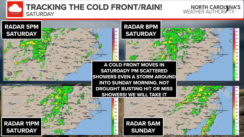
The timing will be mainly after lunch into the late evening. I've attached the future radar. Don't take it literally; it just gives you an idea of the scattered storms in nature. I'll pass along updates.


-Ethan

Mountains

110°F

Raleigh area

CADEN NELSON

CADEN NELSON

Forecast Friday November 21st.

Our weather changes somewhat; it is a new day ahead, and finally the weekend. Happy Friday, North Carolina! We are seeing a few scattered showers around this morning across parts of the center and northern areas of the state, these will move out through the rest of this morning and we will be left with partly to mostly cloudy skies. Highs will be mild and above average today in the 60s and 70s for most of the state. It should be a dry afternoon, later this evening late this evening we will watch for a couple of showers around especially in the Central and Western areas but seem to hold off until late evening and into the overnight hours.


-Ethan


1 Comment


Sue Ross
Nov 21, 2025

Thank you, Ethan. You do a great job, and it is always helpful to get your weather analysis emails. I live at the coast, and your hurricane/nor'easter/temperature posts are particularly welcomed! Sue

Like

Don't Miss a Forecast

Subscribe to emails so you don't miss a thing!

  • Facebook
  • Twitter
  • Instagram

Thanks for subscribing!

bottom of page