top of page

Active Weather is ahead; rounds of storms are likely, with some Flash Flooding possible.

Ethan Clark

July 21, 2026 at 8:08:00 PM

Alright guys, let's talk, since it appears everyone in their brother and 3rd cousin once removed has plans this week and into the weekend! Unfortunately, if you have outdoor plans, you'll be at the mercy of Mother Nature for the next few days. An approaching front will bring a very active period of weather through Saturday at least across North Carolina, and if you haven’t had rain yet by Saturday, I am pretty confident you'll have rainfall!


WHAT: A front will move into the state and stall Wednesday night into Thursday; where the stalling occurs will greatly determine who sees potentially significant rainfall through Saturday, which would also have the potential to have Flash Flooding, which is currently favoring somewhere across Central/Eastern NC. Even with drought condtions excessive rainfall just runs off and results in Flash Flooding. Yes, we can flood in droughts.


Wednesday PM/Evening (Image 2): Scattered showers and thunderstorms will develop, with a limited severe weather risk, with damaging winds as the main threat along the front, which appears to be stalled over parts of Central/Eastern. A level 2/5 risk of Severe Weather has been placed by the Storm Prediction Center; there could be a brief/limited Tornado risk Wednesday evening into the overnight hours (watching)


Thursday: Waves of on-and-off showers and thunderstorms will be possible across the state on and off, favoring Central and Eastern NC. Some could be heavy at times, resulting in potential flash flooding for some. Low severe risk at this point and much cooler temps in the 70s/80s for most areas due to considerable clouds.


Friday: The highest storm chances/rain will be in Central and Southern/Southeastern/Eastern sections of the state. Not a washout, but storms definitely around.

Unsettled weather will continue into the weekend; not a washout by any means, but better chances for more storms and rain the further south and east you are.


The Bottom Line: We need the rain, but all at once could result in some Flash Flooding. I'll be watching over the coming days and pinpoint where exactly as we get a clearer picture. Stay tuned for updates; here are just some thoughts!

-Ethan

Mountains

110°F

Raleigh area

CADEN NELSON

CADEN NELSON

Rain chances return for the first time in 20 days!

🌧️ Did someone do the rain dance? For the first time in over 20 days, I am forecasting scattered rain showers and even a thunderstorm chance Saturday PM into Sunday morning across the state. So what's the deal on Saturday? Most areas start off dry; in fact, most of the day should be dry. A cold front will move across the state Saturday PM into Sunday morning! It'll spark scattered showers and thunderstorms across the state, moving from west to east. The showers and even a thunderstorm will be hit-or-miss, but some spots could get a nice burst of rain Saturday Night into Sunday. No washout, but be on the lookout for scattered showers and even a thunderstorm around. Severe weather is not likely!
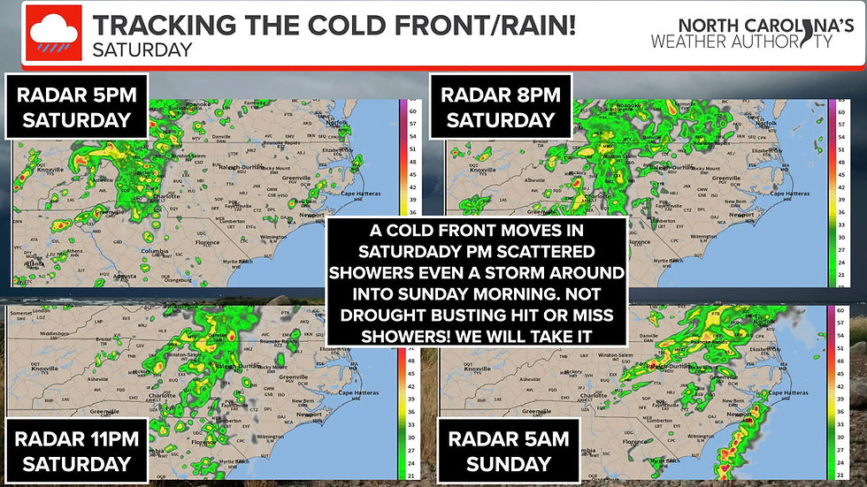

The rainfall amounts won't be all that impressive, and in fact, it won't be even across the state as it is scattered, so some folks will see a nice rain generally less than an inch, while others will see little to nothing. That's just how it goes, folks. So if you have late outdoor/Saturday night plans be prepared to potentially see passing showers or even a storm especially Central and Western areas with the Eastern sections of the state best chance overnight Saturday into Sunday morning!


Everything clears out mid-morning Sunday, and we will turn cooler and drier! Below is a look at a few future radar times. Don't take it literally, but it gives you a good idea of how it'll be scattered in nature! I'll pass along some radar updates at times!


-Ethan


Comments


Don't Miss a Forecast

Subscribe to emails so you don't miss a thing!

  • Facebook
  • Twitter
  • Instagram

Thanks for subscribing!

bottom of page