Coastal Low to bring gusty winds, rain, statewide and the risk of Coastal Flooding to the Outer Banks
- Ethan Clark

- Oct 27, 2025
- 2 min read
Coastal Low to bring Coastal Flooding and gusty winds to parts of the state tonight into Wednesday, the most significant concern for Coastal Flooding is along the Outer Banks. Rain is expected statewide from this, but there is once again a concern for Coastal Flooding, mainly along the Outer Banks, through Wednesday during high tides.

📌Coastal Flood Warning has been issued by the National Weather Service starting this morning through Wednesday evening for all of the Outer Banks south of Oregon Inlet (Hatteras and Ocracoke Islands) NE Winds will start to pick up today and continue to increase through Tuesday moderate to locally significant impacts are possible along the Outer Banks from Coastal Flooding during high tides in the vulnerable areas of the Outer Banks.
📌2-4FT is Coastal Flooding is possible in areas South of Oregon Inlet on Hatteras and Ocracoke Islands. There will be some ocean overwash, especially in the prone areas of Ocracoke, Hatteras, Buxton, Avon, Rodanthe, Waves, Pea Island, and Oregon Inlet. There will be times when Highway 12 could flood during high tide on Pea Island, Buxton, and the North end of Ocracoke, making it impassable at times tonight through Wednesday during high tides.

📌There will be some minor 1-2FT coastal flooding along the southern Pamlico Sound, Core Sound, Neuse/Bay Rivers and
Pamlico/Pungo Rvrs through Wednesday from gusty winds.

📌WINDS: Gusty winds are possible statewide through Wednesday, but the strongest winds will be along the coastal areas, particularly the Outer Banks. 40-60MPH (DARK RED) Wind Gusts will be stronger on the Outer Banks thanks to being closer to the low, so 45-60MPH wind gusts are possible Saturday-Monday mainly. Loose outdoor objects (trash bins, signs, furniture, flags, Halloween decor) can become airborne and cause minor damage. High-profile vehicles (box trucks, RVs, trailers) can be difficult to control on bridges. There could be some scattered power outages from this. Inland areas, some gusty winds will be around, but nothing really concerning, just blustery and chilly.
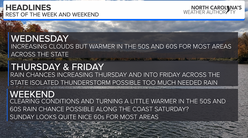
The Bottom Line: More Coastal Flooding is expected for the vulnerable areas of the Outer Banks. Once again, I hate it, but that has been the theme this year. If you have plans on the Outer Banks in the next few days, be prepared for some impacts along Highway 12. Everyone will see rain on and off the next 2 days across the state, nothing too concerning with the rain; we need it. I'll pass along some radar updates as usual over the next few days!
-Ethan


Comments