Hurricane Erin to bring impacts to parts of the North Carolina Coastline
- Ethan Clark

- Aug 18, 2025
- 5 min read
Major Hurricane Erin Update: Good afternoon all. I know there are a lot of concerns regarding Hurricane Erin. I am going to walk you through the impacts county by county/town by town below. North Carolina impacts are likely mainly along the beaches, though. This should get you everything you need to know. I've spent a lot of time this morning looking through data and trying to make and distribute the best forecast possible.
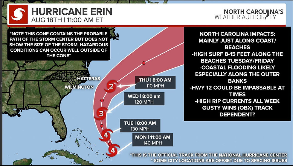
🌀 Hurricane Erin has strengthened back to a Category 4 Hurricane with winds of 140 MPH and a pressure of 935 MB. It is located 880 Miles SSE of Cape Hatteras, North Carolina, according to the 11 a.m. update from the National Hurricane Center. Erin is moving toward the west-northwest at 10 mph. A turn to the northwest is expected later today, followed by a turn to the north on Tuesday. On the forecast track, the core of Erin is expected to pass to the east of the southeastern Bahamas today and move between Bermuda and the east coast of the United States by the middle of the week.

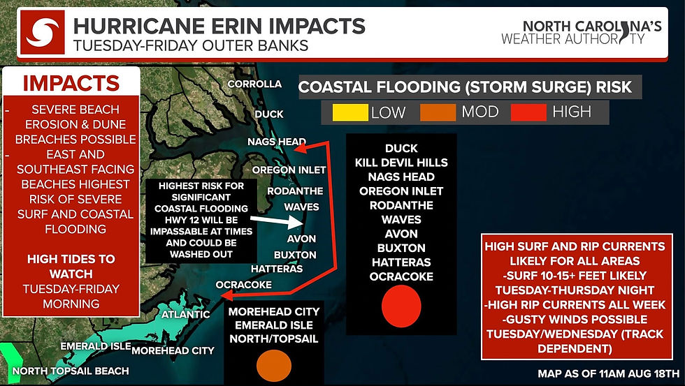
📌 North Carolina Impacts (Image 1 Outer Banks/Crystal Coast Impacts.)
COASTAL FLOODING (Storm Surge) The greatest impacts from Hurricane Erin will be Related to Coastal Flooding (Storm Surge) concerns.
- Coastal Flood Watch has been issued for Coastal Carteret, Coastal Onslow, Coastal Hyde, and Coastal Dare County. It starts on Tuesday and lasts through Thursday night. Looking at the latest data, the most concerning time for Coastal Flooding will be Tuesday into Thursday night during high tides.
Outer Banks (Hatteras & Ocracoke Islands, south of Oregon Inlet most vulnerable)
• Coastal Flood Watch in effect Tuesday–Thursday night.
• Greatest risk: East & south-facing beaches (Hatteras, Ocracoke, Buxton, Avon, Rodanthe, Waves, South of Oregon Inlet).
• Highway 12: Likely impassable in stretches, especially low-lying sections. Disruptions may last several days.
• Ferries: Service likely impacted throughout midweek/late week.
• Extreme beach/coastal erosion and damage expected along oceanside.
• Large waves will destroy dune structures.
• Floodwaters may extend inland, flooding homes, businesses, and roads.
• Vehicles may be submerged.
• Protective actions to safeguard life and property will be necessary.
• High Surf: 10–15+ ft Tuesday–Thursday night, strongest on east/southeast-facing beaches.
• Rip Currents: Very dangerous all week.
The National Weather Service in Newport/Morehead City says for Outer Banks Dare and Hyde Counties."Extreme beach and coastal damage is likely along the oceanside, resulting in a significant threat to life and property. Large dangerous waves will likely inundate and destroy protective dune structures. Severe flooding will likely extend inland from the waterfront causing flooding of many homes and businesses with some structural damage possible. Numerous roads will likely be impassable under several feet of water and vehicles will likely be submerged. Actions will need to be taken to protect life and property. Very dangerous swimming and surfing conditions expected, as well as the wave action resulting in significant beach erosion.
This is expected to be a prolonged duration event, with the potential for portions of NC-12 and secondary roads along the Outer Banks, in particular on Hatteras and Ocracoke Islands, to be impassable and/or inaccessible for several days due to significant wave run up. Minor soundside flooding will also be possible if stronger winds develop over the Pamlico Sound."
📌Crystal Coast (Carteret and Onslow Counties): Coastal Flooding is likely, especially during high tides from North Topsail Beach to Atlantic Beach, particularly in areas most vulnerable to Coastal/Surge Flooding, such as a stronger-than-normal King Tide. Oceanside impacts the main. The potential for roads along the immediate coast to be impassable at times, especially around times of high tide. Areas of greatest concern: North Topsail Beach to Atlantic Beach.
📌High Surf of 10-15FT+ likely Tuesday into Thursday night with the greatest surf on East and Southeast facing beaches.
💨 Wind: Gusty winds are likely as Hurricane Erin passes east Wednesday and Thursday, the best time. Outer Banks Dare, Hyde, and Currituck Counties will have some wind gusts of 40-55MPH possible (Image 4) throughout the day on Wednesday and Thursday, which could be locally higher. The winds are not a huge concern as the Outer Banks sees this all the time, but some power outages and minor damage to property can't be ruled out.
Coastal Carteret and Onslow Counties along the beaches wind gusts of 25-40MPH are possible mainly on Wednesday and Thursday, should not be a big deal, just breezy based on the current forecast track. If it shifts a bit west, it could increase slightly, but I'm not expecting much change right now.
Image 3 (Southern Coast Impacts Pender, New Hanover, Brunswick County Beaches)
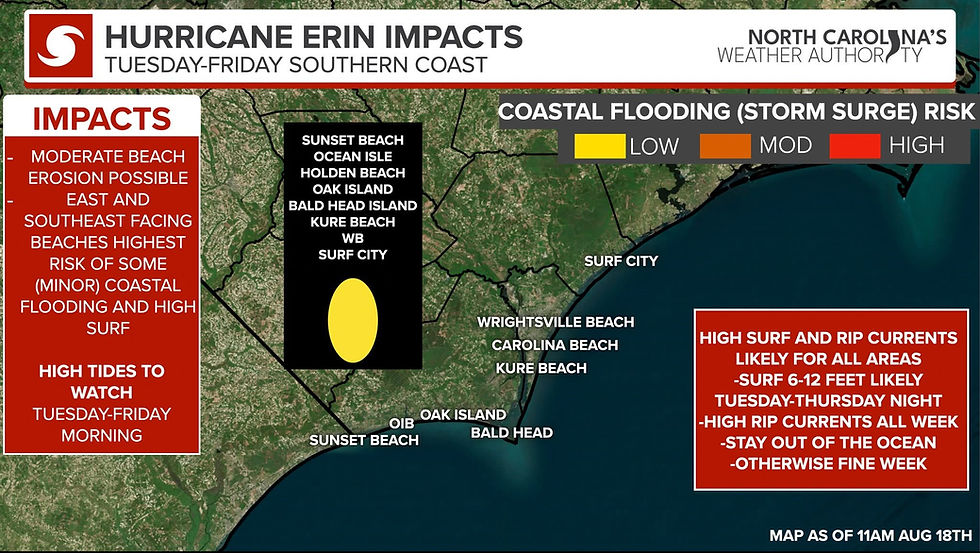
Minor Coastal Flooding is possible during High tides from Sunset Beach, Ocean Isle Beach, Holden Beach, Oak Island, Bald Head, Kure Beach, WB, and Surf City. The greatest risk will once again be South/East-facing beaches. I don't expect too many concerns from coastal flooding along the Southern Beaches, to be honest. However, tides are higher than normal anyway due to the upcoming new moon, so can't rule it out. Not expecting too many impacts, maybe some higher along the Vulnerable areas of Brunswick and New Hanover Counties.
📌High Surf of 8-15FT likely Tuesday into Thursday night.
📌High Rip Currents LIKELY ALL WEEK
📌 Bad Boating conditions, some gusty winds possible on Wednesday and Thursday, but nothing too strong at this point. 25-40MPH wind gusts are possible right along the beaches at times on Wednesday and Thursday.
-----------------------------------------------------------------

Rain/Tornado Threat: I do not expect a tornado threat, and very little rain is anticipated. The best chance for rain is mainly Wednesday night into Thursday, primarily along the Outer Banks areas. There is no concern for inland flooding, inland river flooding, or anything like that area. Most areas will stay sunny for the most part. I want to emphasize that anyone inland from the coast, and I mean away from the actual beach, there is no concern from Erin. There might be a breeze and some sunshine and maybe a passing shower or storm, but really not looking at much concern for rain or wind. Even along the coast, very little rain is expected, and only limited winds, with the strongest winds right along the Outer Banks.
😎 The Bottom Line: Erin will not directly make landfall on North Carolina; folks away from the beaches have absolutely nothing to worry about. Erin is a powerful Category 4 Hurricane, and impacts will spread well beyond the center of the storm. Folks along Ocracoke and Hatteras Island, please follow the advice and leave. The storm will turn north and pass offshore, but its large size means North Carolina’s coast, especially the Outer Banks, will face prolonged coastal flooding, extreme beach erosion, and dangerous surf from Tuesday through Thursday night. Portions of NC-12, particularly on Hatteras and Ocracoke Islands, may become impassable for several days, with ferries also impacted. While direct landfall is not expected, residents and visitors along the coast should prepare for high surf, rip currents, and coastal flooding, with the most significant impacts focused on the Outer Banks. As always, weather forecasting is a science, so if anything changes, I'll be updating. I hope this helps folks out, as there are still some questionable posts floating around.
-Ethan


Comments