Watching a developing coastal low across parts of the coast especially Outer Banks
- Ethan Clark

- Aug 23, 2025
- 1 min read
COASTAL LOW: I am continuing to monitor a developing coastal low that has started to develop along the North Carolina coast. Since my previous update, the National Weather Service has issued a Flood Watch for Tyrrell-Mainland Dare-Beaufort Mainland Hyde-Northern Outer Banks-Ocracoke Island-Hatteras Island-Jones-Pamlico-Northern Craven-Southern Craven-West Carteret-East-Carteret-Inland Onslow-Coastal Onslow, until Sunday afternoon.

-A sneaky little coastal low is developing right along the coast, and models show a period of moderate to heavy rainfall from late tonight into midday Sunday. Looking over the latest data, I think the best area for some Flash Flooding will be across parts of Onslow, Downeast Carteret, Outer Banks Hyde and Dare Counties, while the flood watch does expand further inland, it is really looking like the vulnerable areas of these counties have the best chance of some Flash Flooding.

-This seems to be a little bit under the radar, but I don’t want anyone to be caught off guard. It’ll still be breezy as well, so some minor coastal flooding is still possible through the at least Monday as well during high tides.
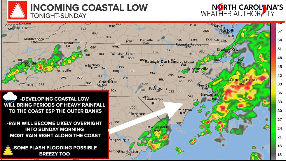
The Bottom Line: The heaviest rain looks to be from Jacksonville to about Rodanthe on the Outer Banks. There could be some pockets of Flash Flooding, especially along the vulnerable areas of Ocracoke and Hatteras Island. These areas could see some enhanced problems thanks to the recent Storm Surge Flooding. If a couple of inches of rain fall it might cause more Flash Flooding, both from fresh and salt water, and make some travel hard through Sunday afternoon, especially along the Southern Outer Banks.
-Ethan


Comments