top of page

Mountains

Strong to severe storms possible this afternoon and evening.

Caden.png

CADEN NELSON

CADEN NELSON

⛈️ Severe Weather Update: Heat and humidity, along with outflow boundaries left over from storms moving through the Ohio Valley, will allow scattered showers and thunderstorms to develop this afternoon and evening across the state and push east. A couple could be strong to severe, with damaging winds being the main threat. The Storm Prediction Center has placed most of North Carolina under a level 2/5 risk of severe weather, and the rest of the state under a level 1/5 risk.


📌WHAT: Cape Values (convective available potential energy (commonly abbreviated as CAPE) is a measure of the capacity of the atmosphere to support the vertical movement of air that can lead to cloud formation and storms.) will soar into the 2000+ J/kg range, which is more than enough for scattered/hit-or-miss showers and thunderstorms to develop, and some wind shear around would support the potential for strong to severe storms. The primary severe threat remains damaging straight-line winds (50-70 mph), localized wet microbursts, and I can't rule out some isolated hail in a storm or two.


Timing mainly after 1/2PM through the late evening from west to east generally, an isolated shower or storm can't be ruled out.


👀 The Bottom Line: It'll be hot and humid today, with scattered pop-up storms developing. Coverage will be 40/50%. Not everyone sees storms, but parts of Central/Western and Central-Eastern NC have a decent shot at a passing storm. If you have outdoor plans, make sure you have a backup plan for what to do if you hear thunder. I've attached the future radar, don't take it literally, but it gives you a good idea. I'll have updates like normal today!


-Ethan

Mountains

110°F

Raleigh area

CADEN NELSON

CADEN NELSON

RECORD COLD THANKSGIVING?

Bundle up and get those heavy jackets out for thanksgiving dinner! Many models are showing the coldest Thanksgiving in nearly a decade for the east coast, that also means here in NC will be very cold.


How Cold? Surface high pressure will build into the state on Wednesday bringing cooler temps on Wednesday highs in the 50's. Before a reinforcing dry backdoor cold front sinks south/southwestward through the area during the day on Thanksgiving. Behind this boundary, a strong Canadian surface high looks to build in from the north ushering in a much colder airmass. With the arrival of the front now expected on Thursday morning with a southern passage by the early evening. Highs will likely occur in the late morning hours across the northern part of the state and northeast part, with temps ranging in the mid 40s across the northern Piedmont with low 50s prevalent as you approach the SC border, many of these highs will be near record low highs for Thursday and November standards. Low temps Friday morning will likely be in the 20s for most locations, with even some lower to mid 20s across the far north.


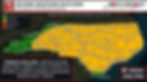
Below is our official forecast for Thanksgiving day, with many of these highs occurring late morning and then slowly dropping off. Image 3 is the European forecast for Thursday afternoon.


Comments


Don't Miss a Forecast

Subscribe to emails so you don't miss a thing!

  • Facebook
  • Twitter
  • Instagram

Thanks for subscribing!

bottom of page