800x500.png)


ARCTIC COLD AND SNOW EXPECTED

Alberta Clipper will bring Arctic cold weather to all of NC and some snow to parts of NC Tuesday and Tuesday night. Here we go again another round of snow is possible for many parts of NC, if you are outside the mountains and foothills I would not get your hopes up. Significant accumulation of snow is not expected outside the foothills and mountains, see more about snowfall amounts in the foothills and mountains toward the bottom of the article.
WHAT: An Alberta Clipper will bring the possibility of snow to the Piedmont, Central, and parts of Eastern NC Tuesday night. This will not be a major winter storm to anyone in NC, instead it will be a light snowfall event Tuesday night. Rain will start for everyone from the Foothills east early to mid Tuesday, once the cold air catches the the rain it will change over to snow. The big concern more than the light snow will be a Flash Freeze Tuesday night lead to black ice and travel problems Wednesday AM.

SNOWFALL: Areas in the blue above will see accumulating snow of a couple of inches
The Mix areas could see a few hours of light snow Tuesday evening and early overnight generally less than an inch with a dusting on grass and elevated surfaces. Rain in the areas in green, would not be surprised if you see some snow mixing in overnight Tuesday.
IMPACTS: Slick spots and black ice is possible across all of NC on Wednesday morning due to Flash Freeze overnight, meaning any water on the ground will freeze.
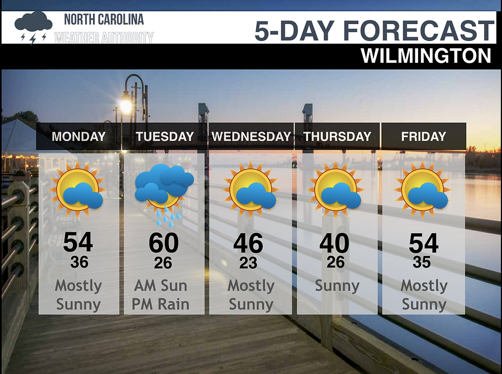
WEEKLY FORECAST: Tuesday statewide will be see rain and snow in parts, the rest of the week will be very cold with lows in the teens Wednesday and Thursday nights. Only one day of precipitation is expected. Below is some local forecasts.. The mountain and foothills snow forecast is below this.




SNOW FORECAST TUESDAY MOUNTAINS/ FOOTHILLS
Another Winter Storm is on the way for Western NC, The National Weather Service has issued a Winter Storm Watch from 1 a.m - 7 p.m. Tuesday for Avery, Madison, Yancey, Mitchell, Swain, Haywood, Buncombe, Macon, Transylvania, Henderson and Graham, Cherokee, and Clay Counties in WNC. Also affected are Northern Jackson and Southern Jackson County, the mountains of Caldwell, Burke, McDowell, Rutherford and Polk Counties.
WHAT: An Alberta Clipper will bring moderate to heavy snowfall to parts of NC Monday night through Midnight Tuesday. Temperatures will fall rapidly and snow could fall through the morning, with precipitation likely tapering off in the afternoon. A brief period of moderate to heavy snow will occur in parts of the mountains of North Carolina
SNOWFALL MAP:
Heavy snow possible. Total snow accumulations of 2 to 5 inches with locally higher amounts of 6 inches in the higher terrain possible.
(1-2) The foothills and Valleys will see generally 1-2" thus a winter storm watch is not in effect.
(2-5) All areas in light blue will see generally 2-5" with highest amounts in the higher elevations towns and mountains.
(6+) Ridgetops of the Smokies and Balsams may see 4 to 6 inches of snow, with slightly higher amounts on the highest ridges.

TIMING: Monday will be manly dry and clear for most of the day with some light snow Monday night
-Tuesday the mountains and extreme western areas will see snow by sunrise Tuesday and it will move east throughout the day. The heaviest snow will fall during the afternoon and evening mainly in the mountains. Rain will also mix in.
IMPACTS: The snow combined with cold air could lead to snow covered roads, especially on less traveled roads. Black ice is expected Wednesday morning in areas that receive less snow. Strong and gusty winds could also lead to some downed trees and power outages. Travel could be very difficult. The hazardous conditions could impact the morning or evening commute. A flash freeze is possible in some high elevation areas, meaning wet roads may quickly become icy and slippery.
Stay tuned for more updates! Due to message problems on the website please message on the Facebook Page North Carolina's Weather Authority


Comments