top of page

Active Weather is ahead; rounds of storms are likely, with some Flash Flooding possible.

Ethan Clark

July 21, 2026 at 8:08:00 PM

Alright guys, let's talk, since it appears everyone in their brother and 3rd cousin once removed has plans this week and into the weekend! Unfortunately, if you have outdoor plans, you'll be at the mercy of Mother Nature for the next few days. An approaching front will bring a very active period of weather through Saturday at least across North Carolina, and if you haven’t had rain yet by Saturday, I am pretty confident you'll have rainfall!


WHAT: A front will move into the state and stall Wednesday night into Thursday; where the stalling occurs will greatly determine who sees potentially significant rainfall through Saturday, which would also have the potential to have Flash Flooding, which is currently favoring somewhere across Central/Eastern NC. Even with drought condtions excessive rainfall just runs off and results in Flash Flooding. Yes, we can flood in droughts.


Wednesday PM/Evening (Image 2): Scattered showers and thunderstorms will develop, with a limited severe weather risk, with damaging winds as the main threat along the front, which appears to be stalled over parts of Central/Eastern. A level 2/5 risk of Severe Weather has been placed by the Storm Prediction Center; there could be a brief/limited Tornado risk Wednesday evening into the overnight hours (watching)


Thursday: Waves of on-and-off showers and thunderstorms will be possible across the state on and off, favoring Central and Eastern NC. Some could be heavy at times, resulting in potential flash flooding for some. Low severe risk at this point and much cooler temps in the 70s/80s for most areas due to considerable clouds.


Friday: The highest storm chances/rain will be in Central and Southern/Southeastern/Eastern sections of the state. Not a washout, but storms definitely around.

Unsettled weather will continue into the weekend; not a washout by any means, but better chances for more storms and rain the further south and east you are.


The Bottom Line: We need the rain, but all at once could result in some Flash Flooding. I'll be watching over the coming days and pinpoint where exactly as we get a clearer picture. Stay tuned for updates; here are just some thoughts!

-Ethan

Mountains

110°F

Raleigh area

CADEN NELSON

CADEN NELSON

Tropical Storm Fiona develops overnight nothing to panic about at this time.

Tropical Update: All anyone is worried about is Tropical Storm Fiona, which developed overnight. Come on, folks; it is over 1,000 miles away from North Carolina; relax; let's just enjoy the nice weather. Here are my thoughts, as usually I am laid back, and there is no reason to hype anything up. I don't know what stuff people are looking at, but I had messages this morning asking if they should board up their homes. I am not trying to get views or anything; just here to state the information we have and explain the models. Tropical Storm Fiona developed overnight; it has winds of 50mph and is moving west at 14MPH. The system is battling a lot of wind shear, and I think it will weaken some in the short term. The National Hurricane Center has issued Tropical Storm Warnings for Antigua, Barbuda, St. Kitts, Nevis, Montserrat, and Anguilla Saba and St. Eustatius St. Maarten A Tropical Storm Watch is in effect for... * Guadeloupe, St. Barthelemy, and St. Martin additional watches might be needed for Puerto Rico and the DR.

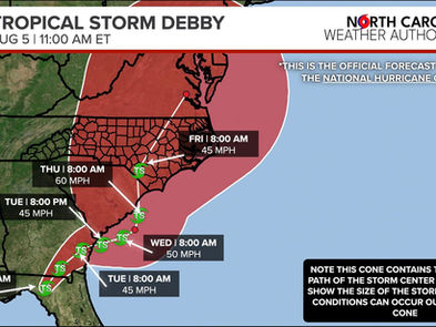
Beyond 4 days the track is very complicated; models range from taking the system north and east out to sea to into the Gulf or near the southeast United States. What will decide the future track would be how strong the system is near the Bahamas; a stronger system would like to curve out to sea a weaker one would not get picked up by the ridge of high pressure and stay closer to land. At this time, it is too soon to know where the system will go beyond 5 day, but morning models are trending out to sea; but there's a lot of ?? but for now, I don't see anything to say if it will hit NC or not odds favor no right now. As always, I'll monitor the system until it is history, and you should, too it is Hurricane season; that's how we roll. Models change every 6 hours. As we get more data, we should have a clearer picture. I'll keep you posted, but no reason to panic right now and stay away from hype posts that show the end of the world. Below is the official forecast cone from the National Hurricane Center as of 11AM.


Comments


Don't Miss a Forecast

Subscribe to emails so you don't miss a thing!

  • Facebook
  • Twitter
  • Instagram

Thanks for subscribing!

bottom of page