


Tropical Storm Arthur forms will bring life-threatening flooding to the gulf coast and some moisture to NC.
- Ethan Clark

- 7 hours ago
- 2 min read
Tropical Update: Tropical Storm Arthur becomes the first Tropical Storm of the 2026 season about 30 miles ENE of Port Oconnor along the Texas Gulf Coastline. The remains of Arthur and an approaching cold front could bring some gusty winds and scattered rain/storm chances to North Carolina Thursday night into Friday. I'll have more on this post. There's far too much hype with this system; we will be just fine in the Carolinas. Tropical Storm Arthur is mainly a rainstorm with a name because it is a very sloppy system.

-Tropical Storm Arthur is expected to produce rainfall totals of 5 to 10 inches, with isolated higher totals near 20 inches, through early Friday from the Mid and Upper Texas coast east-northeast into southern and central portions of Louisiana, Mississippi, and Alabama, along with western portions of Georgia and the Florida Panhandle. This could generate dangerous to life-threatening flash flooding.

-NC IMPACTS: There will be two factors in our forecast for the remainder of the week: a cold front approaching from the NW and the remnants of Arthur sliding by to our south. Thursday will be a hot and humid day with highs in the 90s and feeling like the low 100s, a little cooler in the mountains due to more clouds from the approaching systems. Thursday will be windy across the state with 20-35MPH wind gusts statewide due to the pressure differences and the approaching systems. High Fire Danger likely. Thursday late afternoon/evening, scattered showers and even some thunderstorms will move into the Western areas and push east overnight. Severe threat is very low, but some gusty winds are possible.
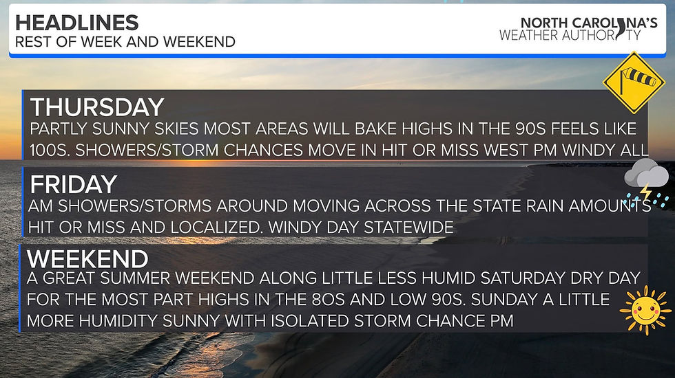
Friday scattered showers and even a thunderstorm will be move through the state through the morning hours into the early afternoon (east). Rainfall amounts don't look like much, but some local spots could pick up an inch (SW mountains) and maybe some east, but many will be quite disappointed in the rain amounts. Gusty winds are likely Friday, 25-35MPH inland with up to 45MPH+ along the coast, esp Friday morning. High Surf and Rip Currents are likely. It is all history by Friday night, I'll pass along updates like normal! No reason to worry here in NC!


Comments