top of page

Strong to severe storms possible this afternoon and evening.

Ethan Clark

June 27, 2026 at 11:23:59 AM

⛈️ Severe Weather Update: Heat and humidity, along with outflow boundaries left over from storms moving through the Ohio Valley, will allow scattered showers and thunderstorms to develop this afternoon and evening across the state and push east. A couple could be strong to severe, with damaging winds being the main threat. The Storm Prediction Center has placed most of North Carolina under a level 2/5 risk of severe weather, and the rest of the state under a level 1/5 risk.


📌WHAT: Cape Values (convective available potential energy (commonly abbreviated as CAPE) is a measure of the capacity of the atmosphere to support the vertical movement of air that can lead to cloud formation and storms.) will soar into the 2000+ J/kg range, which is more than enough for scattered/hit-or-miss showers and thunderstorms to develop, and some wind shear around would support the potential for strong to severe storms. The primary severe threat remains damaging straight-line winds (50-70 mph), localized wet microbursts, and I can't rule out some isolated hail in a storm or two.


Timing mainly after 1/2PM through the late evening from west to east generally, an isolated shower or storm can't be ruled out.


👀 The Bottom Line: It'll be hot and humid today, with scattered pop-up storms developing. Coverage will be 40/50%. Not everyone sees storms, but parts of Central/Western and Central-Eastern NC have a decent shot at a passing storm. If you have outdoor plans, make sure you have a backup plan for what to do if you hear thunder. I've attached the future radar, don't take it literally, but it gives you a good idea. I'll have updates like normal today!


-Ethan

Mountains

110°F

Raleigh area

CADEN NELSON

CADEN NELSON

THE WARMEST TEMPERATURES OF THE SEASON ARE THE WAY

The 80s are coming, the warmest temperatures of the season are the way. Tuesday and Wednesday will be cooler 50s and 60s with some 70s, a few showers possible Tuesday morning. The heat really moves in starting Thursday (the first day of spring) it will feel more like late May rather March Thursday and Friday.


A strong ridge will allow for a southwest wind to bring in the mild air, highs across the state will be in the 70s and 80s for both Thursday and Friday. The end of this week will be a great time to get outside and do some yard work or even let the kids play in the sprinkler. Temperatures will be running 15-20 degrees above average on Thursday and Friday.


Thursday:

Partly sunny and mild with highs in the 70s and 80s cooler in the mountains and along the coast, we will be watching for a few showers possible as well in the afternoon!

Friday:

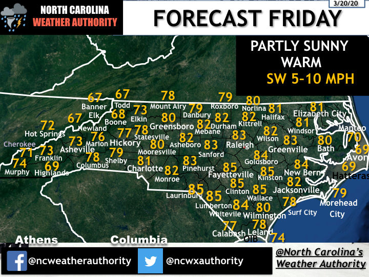
Mostly sunny and warm with highs in the 70s and 80s, a little cooler along the coast and in the mountains.


Pollen:

Here comes the pollen, 4 of the next 5 days will see some of the highest pollen levels we have seen so far this year. Get the tissues ready. Remember a low-grade fever 100 and below can sometimes be related to Pollen, above 100.4 contact medical professionals.


The next 5 days: Tuesday will be mostly cloudy with a few showers possible in the morning on an isolated base. Highs will be in the 60s for most. Wednesday will be mostly sunny and dry with highs in the 50s,60s, and 70s.


Next weekend, Saturday looks nice with highs in the 60s and 70s cooler in the mountains. Sunday looks much cooler with the chance of rain.


Stay tuned to North Carolina's Weather Authority Facebook Page for weather updates daily!


Comments


Don't Miss a Forecast

Subscribe to emails so you don't miss a thing!

  • Facebook
  • Twitter
  • Instagram

Thanks for subscribing!

bottom of page