

The rest of the week into the weekend turning more active
- Ethan Clark

- May 19
- 2 min read
⛈️ Let's talk about late week into the Holiday Weekend. I know there is a ton going on, and the weather greatly impacts most events! Here's my thoughts as of now: No, it won't be a washout, and no it won't rain all day, everyday by any means. The weekend itself is looking like a very typical summertime setup across NC!
Wednesday: Another hot day is expected with highs in the 80s and 90s; most stay dry today. However, a couple of showers and thunderstorms can't be ruled out, mainly across Western NC in the afternoon and evening.

Thursday: A front will approach the state, and we will see a couple of isolated showers statewide Thursday morning, but nothing too much. In the afternoon and evening, with the front around and the heating of the day, scattered showers and thunderstorms will develop, some will be numerous, especially inland into Central and Western NC, lower along the coast until later in the evening, it seems. Highs Thursday in the 70s and 80s for most areas, these storms could have gusty winds and heavy rainfall.
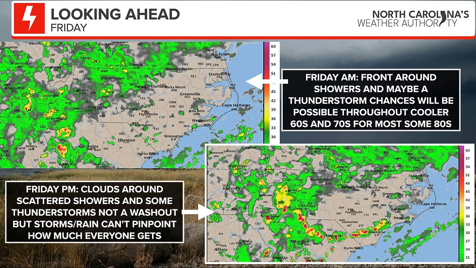
Friday: The front hangs around scatterd showers and clouds around Friday morning in hit or miss with some more showers and storms possible statewide on Friday afternoon and evening.

Saturday-Monday: The front is farther north, but thanks to daytime heating, I am expecting daytime heating showers and storms to be hit-or-miss. These are the summer ones, where they mostly occur mid to late afternoon. This is where no one can pinpoint exactly where they're from until they start developing, but we can get a better idea as we get closer. Highs in the 70s and 80s, Saturday a little cooler west. Sunday/Monday warmer in the 70s and 80s.
The Bottom Line: There is no washout. It will be hard right now to pinpoint the storms and who sees how much. There will be winners and losers with rainfall, and I wish we had the technology to tell me if your backyard will be wet at 2PM on Saturday, but we just need to have a backup plan in place. I'll keep you coming with timing and thoughts over the next few days!
-Ethan


Comments