Strong to Severe Storms are possible on Monday, mainly in the afternoon and evening/early overnight hours across NC.
- Ethan Clark

- Mar 30, 2025
- 4 min read
⛈️ Monday's Severe Weather Update: Good morning all, I've had a lot of questions and concerns about the Severe Weather Potential on Monday. Let me emphasize the potential it is not a slam dunk by any means. The NOAA Storm Predication Center has issued a level 2/5 and 3/5 risk for most of North Carolina on Monday. I was a little surprised about the level 3/5 risk. The setup seems rather complicated, so this has a high bust/fail potential. I'll explain why and what I think below. Storms that do develop on Monday could pose the risk of strong to severe winds and large hail with an isolated tornado threat around.

📌WHAT: A strong mid/upper trough and a trailing cold front will push east across the state on Monday afternoon and evening, setting the stage for the possibility of strong to severe storms across the state. This threat is not a slam dunk, and there is the potential of only a couple of strong to potentially severe storms, but there is also the possibility of more widespread strong to severe storms. So we still need to be aware and watch the radar for the potential on Monday afternoon and evening, but there is no reason for mass panic by any means.
📌Tomorrow, we're cheering for widespread clouds; more clouds will limit the coverage of storms and make the severe risk lower. Models are having a substantial amount of confusion regarding how that'll set up tomorrow. Sun creates CAPE (CAPE or Convective Available Potential Energy is the amount of fuel available to a developing thunderstorm. More specifically, it describes the instability of the atmosphere and provides an approximation of updraft strength within a thunderstorm.)
📌Models range from 500 J/kg of CAPE to more higher amounts due to sun of 1,500+, which would definitely support the potential of strong to severe storms. We should have substantial wind shear aloft, which would support the possibility of damaging winds and large hail along with an isolated tornado threat if these conditions and ingredients are able to be utilized.
👌In severe weather, a cap (also known as a capping inversion) is a layer of warm air aloft that acts like a lid on the atmosphere, preventing warm, moist air near the surface from rising. It's a key factor in storm development — and whether or not storms can develop and turn severe happens. Models show a cap and the potential of lots of dry air aloft commonly referred to as the elevated mixed layer.
Why the Cap Matters in Severe Weather:
A strong cap = storm suppression. No storms can break through.
A weak cap = storms can break through more easily, but might form too early and use up the energy leading to scattered showers which limit severe weather.
A "just right" cap = prevents storms early, but can be broken later (often by daytime heating or a forcing mechanism like a cold front which we will have tomorrow ). When the cap breaks and there's enough instability, it can lead to explosive storm development leading to more widespread storms.
We have the potential that the CAPE breaks early, leading to more showers, and it could also just not break, so we will watch that.
In short, the cap is like putting a lid on a boiling pot. The longer it holds, the more pressure builds—and when it finally pops, it can lead to powerful storms. But if the lid never lifts, nothing happens.
⚠️: All of that being said, we will still have the potential for strong to severe storms on Monday, mainly in the afternoon and evening with a couple of showers possible in the morning. The main risk will be a couple of strong to severe storms with damaging winds and large hail, but an isolated tornado threat does exist as a spin up potential or if a supercell is able to form out of the main line and tap into some shear. I don't expect a tornado outbreak or anything like that right now.
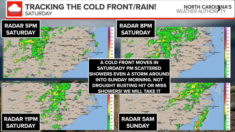
⏰: There will be a few scattered showers and maybe a storm in the morning across Western NC, perhaps a shower across Central and Eastern NC. However, the main timing for strong to severe storms will be west to east through the afternoon and evening hours into the early overnight hours far east. I have added some future radar images below, but don't take them literally.


The Bottom Line: There is a substantial uncertainty regarding for the severe weather potential on Monday, but the threat does exist, and we should stay weather aware on Monday. It could ramp up quickly, or it could not be a huge deal. Please remember this is just a forecast, and there is uncertainty. One ingredient being not as high/strong as forecasted could throw off the entire forecast.
With that being said:
Have Multiple Ways to Get Alerts:
Use NOAA Weather Radios, phone alerts, and apps. Don’t rely on just one method.
Have a Plan:
-Know your safe place (lowest floor, interior room, away from windows).
-If you're in a mobile home, plan to shelter elsewhere.
-Practice your plan with your family.
Prepare an Emergency Kit:
-Include water, flashlight, batteries, first aid, medications, and important documents.
Don’t Wait Until the Storm Hits:
Take watches seriously — they mean conditions are favorable. Warnings mean it’s happening now — take cover immediately.

I'll be monitoring the models, the radar, and any changes to the forecast over the next 24 hours and will provide updates as needed, like I always do. I'll be glued to it, and work to provide updates to keep you and your family safe.
-Ethan


Comments