
SIZZLING 4TH AHEAD WITH NO SOCIAL DISTANCING FROM THE 90S
- ncwxauthority

- Jul 1, 2020
- 2 min read
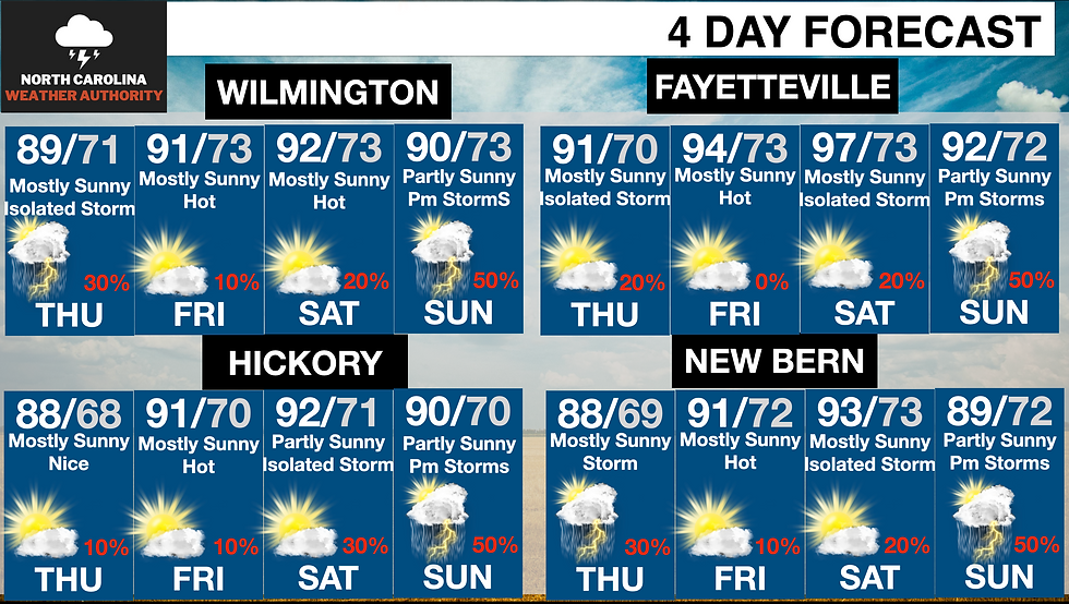
It's July, and the good old North Carolina summer weather is in full swing, perfect for outdoors anything you have planned. Looking ahead at the next four days and the 4th of July weekend, the rain chances will drop, and the temperatures will soar. The next four days forecast graphics are located below (the bottom)
WHAT: A developing High-Pressure system will move in over the Ohio valley, here in NC, due to the wind pattern downsloping will allow areas outside of the mountains to warm up quickly. Highs will be in the 80s and 90s Thursday-Sunday with the hottest days Friday and Saturday. Storm Chances will be few and far between, why because of a capping which prevents the development of thunderstorms. The best chance for some PM storms will be Thursday and Sunday. Friday and Saturday will have a strong cap in place, and only a rogue thunderstorm will be possible.
Below is an overall view of the set up on Saturday, as you can see temperatures will, in fact, be running 5-10 degrees above average in the 90s with 80s in the mountains.

Thursday- Partly to Mostly sunny and warm with highs in the 80s and 90s an isolated thunderstorm is possible along the coast and in the mountains.
Friday-Saturday: Mostly sunny and hot with highs in the 80s and low-mid 90s across the state heat index values in the upper 90s. An isolated rogue thunderstorm is possible in the afternoon and evening. A great day for the beach, lake, or pool!
Sunday- Partly Cloudy with highs in the 80s and low 90s, there is a higher chance of scattered thunderstorm in the afternoon and evening. They can produce gusty winds and heavy rainfall, I'll have more as we get closer.


Have a great 4th of July Holiday!


Comments