800x500.png)


PATTERN CHANGE COMING; WIDESPREAD FREEZE EXPECTED FOR PART OF THE STATE FRIDAY
- ncwxauthority

- Oct 28, 2019
- 2 min read
Our warmer conditions are about to be on there way out starting Friday; a significant pattern change is on the way for the state. Tuesday will be mostly cloudy, becoming overcast with highs in the 70s and 60s across the state. We will watch for the chance of a few isolated showers in the southern part of the state and the mountains
Here's a look at the daily forecast map!

Wednesday and Thursday (Halloween) we are watching an approaching cold front. The timing of the cold front will be critical to the Halloween forecast. Wednesday will be mostly cloudy with showers mainly in the afternoon across the state heaviest amounts in the mountains. Thursday, our next strong cold front arrives, the GFS is still a few hours faster than the Euro.
SCENARIO 1: The GFS has the cold front passing through the state by early afternoon, this would shut off the rain by evening. We would see mainly dry conditions for Halloween night!
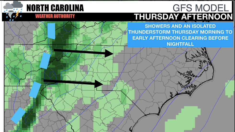
SCENARIO 2: The Euro, which is slower than the GFS, would bring the cold front through the state mid to late afternoon and evening. This would bring showers and thunderstorms to the state during the afternoon and evening hours.
BOTTOM LINE: Rain is likely on Thursday the exact timing of the rain is still unknown, the amounts will be pretty light outside the foothills and mountains
RAINFALL amounts through Friday:

PATTERN CHANGE: No matter when the cold front arrives all signs point toward a major pattern change starting this week. We will likely see highs in the 60s and 50s statewide on Saturday and Sunday, lows below freezing in the mountains and 30s/40s elsewhere. The growing season in the mountains will likely end, the cooler weather looks to stay around as well.
Here's a look at low temperatures for Saturday night into Sunday morning.

GFS Model (weathermodels)
Stay tuned to North Carolina's Weather Authority Facebook page for more updates this week!


Comments