800x500.png)


ARCTIC COLD WILL BRING THE COLDEST TEMPERATURES OF THE SEASON

Weather whiplash temperatures will crash 30-40° starting Friday, the coldest air of the season with temperatures not normally seen until January. A vigorous cold front will move through late tonight ushering in the very cold air. Highs will struggle to get out of the 40s on Friday for many. Near-record cold expected by the middle of next week.

COLD ARRIVES: Friday night we will see the coldest air of the season statewide lows in the 20s and 30s, it will be a shock to the system. Widespread freeze is expected for everyone but the coast; the growing season will end. Please prepare your homes for cold temperatures and bring pets and animals.

WEEKEND: The weekend and Monday will be the in-between period, rather cool highs in the 50s and lows 60s with lows in the 30s and 20s Saturday night/ Sunday night 30s and 40s. It will be sunny for everyone though! Monday will be the warmest with highs in the 60s.

NEAR RECORD COLD: The second round of cold will likely be near-record cold with the coldest air since January/ February. A vigorous cold front will move through the state during the day on Tuesday bring in the significant to dangerous cold. Highs will struggle to get out of the 30s on Wednesday for many. All models support widespread cold temperatures Tuesday-Friday with low temperatures in the low to mid-20s on Tuesday night.
Wind Chills: Models are suggesting near dangerous windchills Wednesday and Thursday in the teens to single digits. Here's a look at my current forecast for Wednesday morning.

This cold has the potential to be approaching record levels, here's a look at the GFS model predictions temperatures running about 20-30° below normal for everyone.

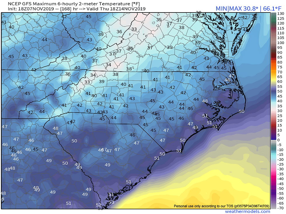
Highs on Wednesday will likely stay in the 30s for most.

Potential Highs Thursday
Winter Weather follow up:
Well, it's that time again where we see all the talk of the "S" word. Here's my honest truth, I don't need to hype the situation or get "clicks." In the winter, to me anything beyond 3-4 days is no man's land. Right now, a few models have been throwing the idea around of maybe some wintery precipitation next week. No one knows, even if they say Alert snow is coming. I don't believe in covering or posting about snow more than 3 days out, all of the postings before that is hype. This page is for the real honest truth not some hyped dramatic information on something that might happen from a model 5+ days away. I'll be with you all winter long, but not hyping anything. Real weather here the real truth. The potential for at least some light snow is definitely possible next week in the mountains, that's about it as of now.

Stay tuned for updates on North Carolina's Weather Authority Facebook throughout the week and beyond! Thanks for the support!


Comments