800x500.png)


SEVERE NOR'EASTER EXPECTED TO BRING MAJOR IMPACTS TO THE NC COAST THIS WEEKEND
- ncwxauthority

- Nov 16, 2019
- 3 min read
Conditions are beginning to go downhill quickly along the North Carolina Coast, we have already had reports of winds gusting to 50MPH and ocean overwash on NC Highway 12 near Avon. The coastal low (Nor'easter) is beginning to develop along the coast, major impacts are anticipated especially from Morehead City north to the Outer Banks. The coastal low will begin to move up the coast, starting tonight, bringing heavy rainfall and high winds to the coast, especially from Morehead City north to the Outer Banks. A major concern is a potential for severe Storm Surge significant sound-side, and ocean overwash is expected. The greatest impacts will be from the Crystal Coast north to the Outer Banks. A High Wind Warning and Coastal Flood Warning has been issued, everything you need to know below. The southern Coast (Wilmington, Pender, New Hanover, and Brunswick County, expect only minor impacts some gusty winds 40-50MPH 2-4" of rain and no coastal flooding. This is a life-threatening situation for the Outer Banks. Everything you need to know below, including timing out the Storm Surge

There's high confidence in life-threatening Storm Surge this weekend to the Outer Banks. A long-duration high wind event out of the north and northeast will cause significant Storm Surge. While ocean overwash will be the primary threat,
soundside flooding will also be a large concern across Southern Hatteras Island, Ocracoke Island, Downeast Carteret County and into the Lower Neuse River. Impacts include potential flooding of homes and businesses in close proximity to the waterfront.
In some areas on the oceanfront north of Cape Hatteras, battering waves with significant wave runup will cause damage to property. Numerous roads will be impassable under several feet of water and vehicles will be submerged. Some neighborhoods will be isolated and some areas may need to be evacuated. Portions of NC 12 will likely become inundated and impassible.
COASTAL FLOODING (STORM SURGE) Significant to life-threatening coastal flooding expected along the Outer Banks starting Friday night through Sunday. The flooding will be both from ocean overwash and sound-side flooding. Potential for life-threatening storm surge, 3 to 5 feet above the ground with higher amounts possible High surf, beach erosion and ocean overwash likely. Locations of greatest concern, Ocean side locations from Duck down to Ocracoke Island. Sound Side locations in Hatteras and Ocracoke Islands.
IMPACTS Up to 3 to 5 feet of inundation above ground level, with locally higher amounts, is possible in some areas near shorelines and tidal waterways resulting in an elevated threat of property damage. Rough surf, beach erosion, and ocean overwash are possible along the oceanside, and portions of Highway 12 could be inundated and impassable at times. Severe flooding will extend inland from the waterfront causing flooding of many homes and businesses with some structural damage possible. In some areas, battering waves will cause additional damage to property. Numerous roads will be impassable under several feet of water and vehicles will be submerged. Some neighborhoods will be isolated and some areas may need to be evacuated. Flooding will extend inland from the waterfront threatening some homes and businesses. Numerous road closures and flooding of vehicles will be possible.
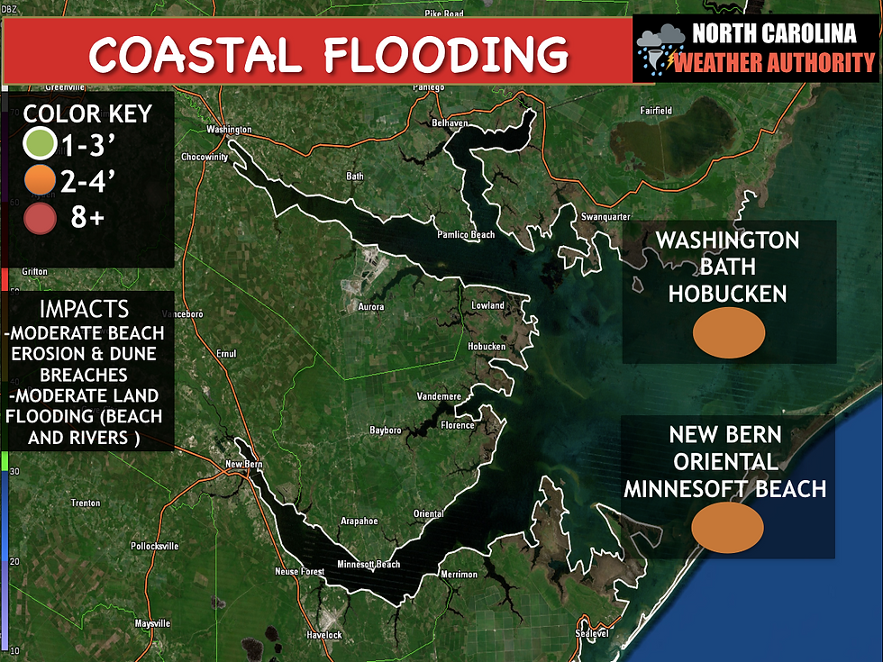
GREATEST IMPACTS: Strong northerly winds will bring major Coastal Flooding to the Outer Banks. Soundside Outer Banks south of Oregon Inlet to Carteret County. The Lower Neuse River and the southern shores of Albemarle Sound and Alligator River. Significant oceanside impacts are expected along the Outer Banks from Cape Hatteras north to Oregon Inlet. High 12 will become inundated and impassible in some portions this weekend.

High Tide Schedule:
Duck: Next High Tide 10:02 PM Saturday/10AM Sunday ( Major Flooding expected with this one) 10PM Sunday (Major Flooding Expected with this one) Monday 10AM still expecting major flooding.
Hatteras: Same as above +-1 hour
Rodanthe: Same as above +-1 hour

High Winds are likely mainly along the coast from Carteret County to the OBX Hyde and Dare counties, winds could gust up to 60-70MPH along the immediate coast. Impacts power outages likely will be possible and some damage to weakened properties. The strongest period of winds will be from Saturday morning to Sunday night along the Outer Banks.

Wind Advisories have been issued for the Southern Coast, 35-45MPH wind gusts some locally higher speeds along the coastal areas. Power outages are possible.
Statewide Wind:

Break down of Impacts per area:


Full updates all weekend long on Facebook, please stay safe and stay tuned. If you have pictures or videos send them on the Facebook page.


Comments