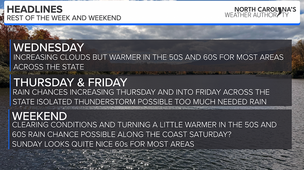
SEVERE WEATHER POSSIBLE TONIGHT; THREAT INCREASES
- ncwxauthority

- Jan 11, 2020
- 3 min read
A robust spring-like storm system will move into NC this evening through the early morning of Sunday. A few storms could be strong to severe with damaging winds and an perhaps 1 or 2 tornadoes. Everything you need to know below.
WHAT: I'm closely watching a storm system moving across Mississippi, Tennesse, and Alabama this morning, bringing tornadoes and damaging winds to that area. The system will move into NC this evening into early Sunday with that a few storms could be strong to severe. I know many people are concerned that it will be the widespread nature as the deep south, it will not be! The Storm Prediction Center has placed the whole state in a level 1/5 threat for Severe Weather and just upgraded Greensboro/ Charlotte west to a level 2/5 risk of Severe Weather, this does not mean the world is going to end or widespread severe weather outbreak.

SEVERE WEATHER: We have the potential for a few storms becoming severe. Our Severe Weather threat is much lower than the deep south due to the fact it is occurring during the overnight hours. Instability comes from warm moist air with the sun setting you to start to lose that so the thinking is the storms will lose some of the energy. That being said, I'm still thinking we see a few storms that could be severe. However, another critical "ingredient" is shear. Damaging winds and isolated spin-up tornado are possible in the area circled on the map below. A QLCS, which is a fancy name for a squiggly line of storms, will have the greatest threat for some damaging winds gusts and isolated embedded Tornado (though that threat is pretty low, but not zero). Due to a more line of storms and not individual storms, the threat for damaging winds is greater. The greatest threat will for Severe Weather will be from west of Raleigh to about Clay County, east of Raleigh the threat goes down significantly due to the loss of "storm energy"
IMPACTS: The main threat will be damaging winds 60-70 MPH with a few storms tonight into early Sunday. However, I'm watching the potential for 1 or 2 tornadoes as well. The best area to see an isolated tornado will be in the red hatched box, where the parameters are higher. While this event will be limited in nature, with it occurring during the overnight hours, it is more concerning because folks are in bed. Before you go to bed tonight, make sure you have a way to get warnings.


TIMING: Storms will move into the mountains late Saturday evening and push toward the Charlotte Greensboro area after 8PM and into the Triangle and eastern NC areas after 11PM

Bottom Line: We have a threat for severe weather, but only an isolated base due to the fact its overnight hours. This will not be a widespread event; most will not see rain, a small population could see a severe storm tonight.
Don't freak out I got you covered! Please stay tuned for updates as things and will change, 24/7 updates throughout the storms will occur on North Carolina's Weather Authority. I am closely monitoring the situation, make sure you have many ways to receive severe weather alerts tonight. It is imperative that you keep checking for updates tomorrow. Questions please message on the Facebook page not on the website!

CALL TO ACTION: People must have a way of hearing warnings, and that way should never, ever be a siren. Their purpose is only to reach a limited number of people outdoors. Every North Carolina home and business must have a NOAA Weather radio, properly programmed and with a fresh battery backup. Be sure WEA (Wireless Emergency Alerts) are enabled on your phone (check notification settings)... even with no good weather app installed you will receive a tornado warning with a loud audible alert.
If you live in a manufactured home, you have to GET OUT if a tornado warning is issued. Have a shelter identified, or other place identified that is open when you are at risk. Know how to get there quickly.


Comments